


People in the Great Plains will get a harsh reminder this week that Ol’ Man Winter isn’t ready for spring to begin (after all, it’s technically still nine days away). Signs point to a strong storm developing out west, turning into a blizzard as it heads toward portions of the nation’s heartland by mid-week. Carriers will have to reroute drivers, and short-term disruptions in freight movement are likely. There’s a good chance of power outages in many areas, as well as trees and utility lines blocking roads.
Day One
After a relatively quiet start to the week, a potent low pressure system over the Southwest will get even stronger on Tuesday as it heads toward the Four Corners region. Heavy snow will spread across the Rockies of Colorado and Wyoming, as well as the eastern plains of these states from Tuesday night through Wednesday. Western sections of Nebraska and South Dakota will also be target areas during this time frame.
Areas of freezing rain and sleet could develop near the transition zone between the cold part of the storm and the warmer, rainy side to the east. The result would be a narrow band of icy conditions extending from just east of Denver to around North Platte, Nebraska, crossing I-90 into Pierre, South Dakota.
Exact snowfall amounts are hard to pinpoint at this time, but parts of eastern Colorado could get hit with at least five to 10 inches. Along sections of the I-80 corridor from eastern Wyoming into western Nebraska – from the Laramie Range and Cheyenne into Scottsbluff – snow totals could reach 10 to 15 inches, with six to 12 inches in the Black Hills of South Dakota and the Rapid City area.
Winds of 50 to 65 mph will create whiteout conditions, possibly reducing visibility to zero. The winds will also make deadheading very risky for any drivers who have to haul through this region.
The National Weather Service (NWS) has issued Winter Storm Watches, but will probably increase them to Winter Storm Warnings or Blizzard Warnings as the storm takes shape.
Day Two
On Thursday, heavy snow and strong winds will develop in eastern parts of North and South Dakota, as well as in northern Minnesota. It’ll be a close call as to whether Minneapolis-Saint Paul get snowed in, or there is just a slushy mess. Meanwhile, snow will fade across the areas hit on day one, but winds will remain powerful, with blowing and drifting snow not easing up.
The NWS hasn’t posted any winter weather alerts for day two impact areas – it’s too soon – but computer models are hinting at snow totals of six to 12 inches with wind gusts reaching 50 to 60 mph. The worst travel on Thursday will likely be on I-29 from Grand Forks to Sioux Falls, in addition to I-90 from Bismarck to Fargo. Check the latest NWS alerts on this interactive map, and check chain laws here for the latest updates on winter driving.
Snow should dissipate across “day two” areas by Thursday night, but winds will stay fierce through Friday before the storm moves into eastern Canada. By this time, it’s influence on the U.S. will be gone, but perhaps not forgotten.
Impact on Freight

The latest FreightWaves SONAR data indicates that carriers are not accepting many loads into markets (ITRI.USA) where the midweek blizzard is expected to strike (area inside the red box in the map above). This may be, in part, because they’re planning ahead and don’t want to send drivers into the storm. Look for possible increasing rejections through the week.
Other Significant Weather This Week
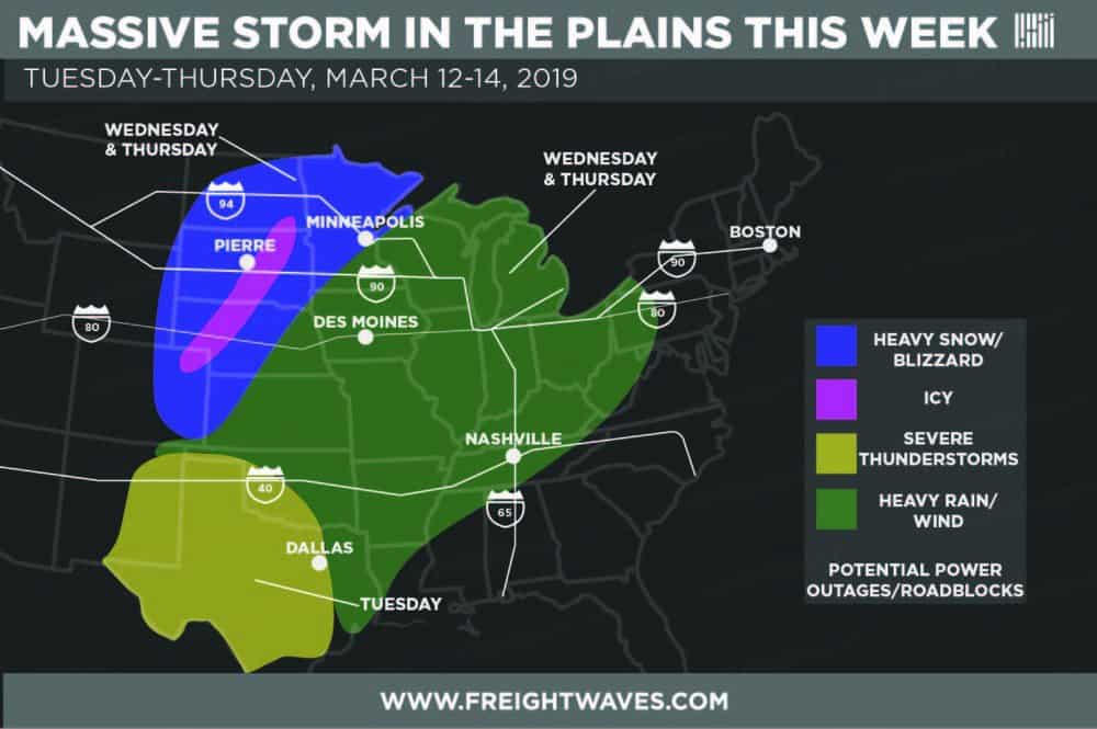
On the warm side of the Great Plains storm, severe thunderstorms could pummel parts of Texas and eastern New Mexico on Tuesday afternoon and Tuesday night. Large hail, damaging winds and isolated tornadoes are possible, in addition to heavy downpours and flash flooding along the I-20 and I-40 corridors. Look for heavy rain and strong winds across portions of the Southeast, Midwest and Northeast on Wednesday and Thursday.
Look for more weather updates during the week on the FreightWaves website!
