


Hurricane Willa is on a collision course with western Mexico, and is likely to cause life-threatening storm surge, flooding, landslides, and wind damage beginning Tuesday. Then, the remnants move into the U.S.
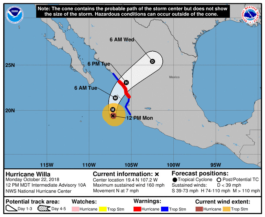 Forecast for Hurricane Willa, as of 2 p.m. EDT, October 22. (Source: NOAA)
It started as a weak Tropical Storm over the weekend but quickly got stronger. Willa is now a Category 5 hurricane on the Saffir-Simpson scale, with powerful sustained winds of 160 mph as of early this afternoon. It’s the tenth major hurricane (Category 3 or higher) of the eastern Pacific season. Willa might lose some strength before making landfall Tuesday, but there’s a good chance it will still be a major hurricane at that time.
Right now it’s close to the small islands of Isla San Juanito, Isla María Madre, Isla María Magdalena, and Cleopha Island. The latest outlook from the National Hurricane Center has Willa striking the mainland somewhere between Mazatlan (state of Sinaloa) and San Blas (state of Nayarit) which is just north of the resort city of Puerto Vallarta. Tropical storm force winds of 39 to 73 mph will begin to affect these areas from this afternoon into tonight – prior to landfall – with hurricane force winds beginning Tuesday.
Willa will likely cause catastrophic damage and widespread power outages. People in these areas of Mexico’s west central and southwest coasts should prepare for the following:
-
Storm surge: Extremely dangerous storm surge along Tuesday or Tuesday night, especially near and to the south of where the center of Willa makes landfall. Near the coast, the surge will be accompanied by large and destructive waves.
-
Rainfall: Possible storm totals of 6 to 12 inches, with local amounts to 18 inches,
across portions of western Jalisco, western Nayarit, and southern Sinaloa in Mexico. This rainfall will cause life-threatening flash flooding and landslides. Farther inland, Willa is expected to produce rainfall amount of 2 to 4 inches across portions of Zacateca, Durango, southeast Chihuahua, and Coahuila in Mexico, with local amounts to 6 inches possible. This rainfall could cause life-threatening flash flooding. -
Surf: Large swells generated by Willa will continue to affect portions of the coast of southwestern and west-central Mexico during the next few days. These swells are likely to cause life-threatening surf and rip current conditions.
Agriculture could take a big hit in the target areas. According to Nations Encyclopedia, Sinaloa is one of the top sugarcane producing states, and agriculture there accounts for 21% of the economy. The state of Nayarit is the leading producer of tobacco in Mexico. Both states grow many other crops – tomatoes, beans, corn, wheat, potatoes, squash, avocados, mango, bananas, and papayas – some of which are grown at sea level not far from the coast.
After Willa slams the coast, it’ll lose a lot of steam while moving eastward across Mexico toward the U.S. Winds won’t be nearly as strong (less than Tropical Storm force), but rain will be a potential issue for parts of Gulf coast.
As Willa makes landfall on Tuesday, outer bands on the storm will interact with a separate system in the western U.S., producing some heavy rain in parts of central Texas. Then, as Willa get closer to the Gulf of Mexico, heavy rain is possible from Brownsville and Houston eastward to Lake Charles, Louisiana Wednesday through Friday. Storm totals of 3 to 5 inches could accumulate, with locally higher amounts. Areas of flooding could cause road closures and dangerous driving conditions.
Crops could be at risk along the Gulf coast, too. Southern Louisiana is known for growing sugarcane which is the leading farm product in the state. Other important crops that could get drowned by Willa are rice, soybeans, cotton, and corn for grain. Netstate says around 60% of Louisiana’s agriculture income is generated by crops. Cotton is king in Texas, which produces more of it than any other state, but some farmers there run the risk of crop loss or further delays in harvesting having to wait for bolls to dry.
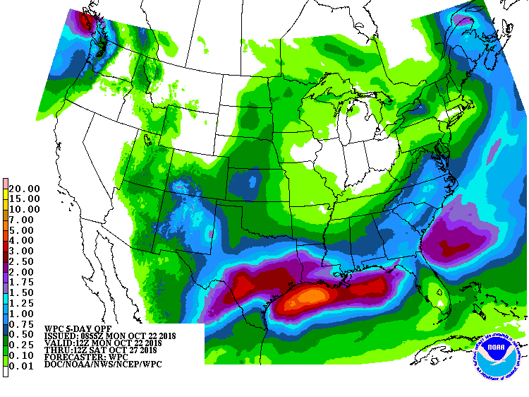 Forecast rain totals through Friday night, October 26. (Source: NOAA)