


The lake effect “snow machine” is at it again, but this is no surprise in January. Nonetheless, driving conditions for truckers will be challenging and treacherous through interior portions of the northeastern U.S. and New England, especially when brutal winds are factored in. Prepare for possible delays, especially out of the Syracuse market where freight volumes have been increasing.
Storm Development and Duration
A strong low pressure system centered over Maine will intensify this evening and tonight. Counterclockwise winds around the low will blow plenty of cold air across the Great Lakes into the Northeast freight region. Those winds combined with moisture over the lakes form the perfect conditions for significant lake effect snow across interior parts of the region tonight through Thursday.
Most of the heavy snow will be in areas just east of Lakes Erie and Ontario, from Erie, Pennsylvania to Syracuse, New York. Other areas in the bulls-eye include, but are not limited to Meadville, Pennsylvania; Jamestown, Oneida, Orchard Park, Oswego, Saranac Lake, and Watertown in New York; Bristol, Burlington, Montpelier, and Springfield in Vermont; points along and north of US-302 in New Hampshire and Maine.
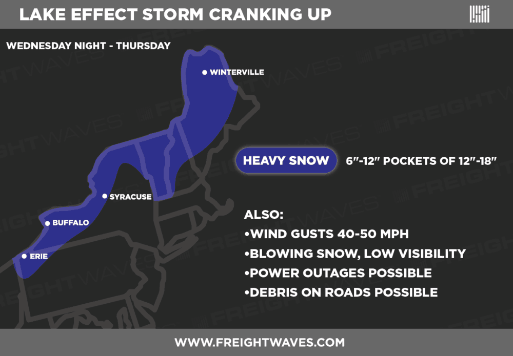
New accumulations of six to 12 inches are likely for most neighborhoods in the dark blue shading on the map above, with some spots receiving 12 to 18 inches. Patchy freezing rain will also develop, so drivers will run into possible icy roads along sections of the following interstate corridors: 81, 86, 87, 89, and 90.
The difference in pressure between the low over New England (around 990 millibars) and high pressure over the Great Plains (around 1034 millibars) is so large that it’s creating very strong winds to accompany the snow. Fierce gusts of 40 to 50 mph will potentially result in the following scenarios:
Blowing snow and low visibility
Power outages
Debris on roads, leading to closures
Besides expecting and planning for delays, drivers should dress warmly. Wind chills will be dangerously cold – around 20 degrees during the day today and Wednesday, near zero tonight. In addition, light snow with freezing drizzle could cause icy spots along the I-95 corridor through southeastern New Hampshire and eastern Maine.
To avoid delays during the storm, drivers should remember to pour winter additive into their diesel to prevent fuel gelling. Also, prepare for brake systems to freeze, and be aware that batteries with low Cold Cranking Amps (CCA) values may have a hard time starting.
Winter Storm Warnings have been issued by the National Weather Service (NWS), and you can check chain laws here for the latest updates on winter driving.
Impact on Freight

Syracuse is a small freight market, but outbound volumes have been growing at a good clip since the beginning of the year. More noteworthy is the overall upward trend in volume over the past several months – nearly 26 percent higher since the beginning of August 2018, according to FreightWaves SONAR data. So, carriers need to be aware there will be a bit more traffic than usual coming from this area, and drivers will likely be dealing with increased truck traffic along with the bad weather.
