


Overview
A storm that flooded southern California with record rainfall the past two days will wreak havoc across the Gulf Coast and the Southeast this weekend. Along with more flooding, it will produce ice and heavy snow in parts of the Southeast where very cold temperatures will be in place. This could turn out to be a crippling event, leading to travel delays and cancellations, as well as disruptions in regional supply chains.
Analysis and Timing
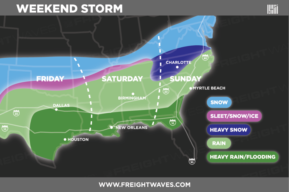
As moisture from the Pacific Ocean and the Gulf of Mexico continues to feed into the storm, rain will freeze on contact with roads and other surfaces that will be at or below freezing on the cold side of the storm. This will lead to light ice accumulation Friday night from around Lubbock, Texas eastward to Oklahoma City and northern Arkansas, changing to snow on Saturday. The ice and snow threat move into northeast Georgia, western North Carolina, as well as northwestern and northeastern Tennessee Saturday night through Sunday.
The latest outlooks show a quarter inch to a half inch of ice in some of the areas previously mentioned. Large tree limbs and power lines will buckle under the weight of the snow and ice, potentially knocking out electricity to a fairly large portion of the country. The map below is an approximation of timing and location of precipitation types for this storm. Please keep in mind that ice could initially develop in the dark blue shaded area prior to heavy snow.
Impact on travel and the supply chain
Charlotte looks to be the largest metro area—estimated at nearly two and half million people—that will be most severely impacted. Up to six inches of snow are forecast for the city, with twelve inches or more in the highest elevations north of I-40 in western North Carolina. This could be preceded by ice, and a storm of this magnitude might effectively shut down the city for at least a few days.
Despite plenty of capacity, it’s probably too late to get shipments out of the Charlotte market before the storm arrives. Then, once the storm hits, carriers will be unable to move through the region.
As far as rail, Norfolk Southern is getting ahead of the storm, announcing in a customer notice that “Due to the projected path of the storm, and to minimize the impact on train and terminal operations, effective 8:00pm today, Friday, December 7th the ingate lanes at the Charlotte Intermodal facility will close to all shipments. Drivers will be allowed to bobtail onto the facility to outgate grounded shipments.”
The statement goes on to say “All shipments ingating Norfolk Southern origin facilities, billed to Charlotte, will be loaded and advanced to Charlotte as operations and conditions allow. We will not be able to unload and return shipments once they have been loaded. We will continue to monitor the storm and provide updates as the storm progresses.”
Air freight into and out of Charlotte will likely be disrupted, and travelers will need to check commercial flights. Many of them could end up delayed or cancelled.
Lots of snow could is also projected for the Smoky Mountains of east Tennessee, making travel difficult to impossible on portions of I-40 and I-81.
Stay ahead of the storm
The National Weather Service will likely issue the following alerts as the winter storm develops:
-
Winter Weather Advisory: Be aware! Winter Weather Advisories are issued when snow, blowing snow, ice, and/or sleet are expected but conditions should not be hazardous enough to meet warning criteria. Be prepared for winter driving conditions and possible travel difficulties.
-
Winter Storm Watch: Be prepared! Winter Storm Watches are issued when conditions are favorable for a significant winter storm event – heavy sleet, heavy snow, ice storm, heavy snow, blowing snow, or a combination of events.
-
Winter Storm Warning: Take action! Winter Storm Warnings are issued for a significant winter weather event including snow, ice, sleet, and/or blowing snow. Travel will become difficult or impossible. Delay your travel plans until conditions improve.
Look for updates on this interactive map.
Warm side of the storm
Watch out for heavy rain, strong thunderstorms, and potential flooding for portions of Texas, mainly the Dallas, Houston, and San Antonio metro areas through Friday night, as well as western and southern Louisiana. The flood threat shifts to southern Alabama, northern Florida, southern Georgia, southern Louisiana, southern Mississippi, and eastern South Carolina Saturday and Sunday. Widespread areas of four to six inches of rain are possible with pockets of eight inches. Parts of the I-10 and I-20 corridors could end up under water and closed. Travel will also be difficult on portions of I-16, I-65, I-75, and I-95.
