


On Monday, FreightWaves wrote about a potentially damaging blizzard that could rip through parts of the nation’s heartland this week. Well, now it looks as likely as ever it will happen, and the geographical scope and strength of the storm may be bigger than originally thought. People in several states should take this storm seriously and start planning for it now.
On the Ground
This storm will last two days, Wednesday and Thursday (March 13-14), dumping huge amounts of snow across a large region. From near Denver all the way to the Dakotas, totals of six to 12 inches will be common. However, up to 24 inches could pile up from Cheyenne into parts of western Nebraska, with more than 24 inches in the Black Hills of South Dakota (just west of Rapid City).
The blizzard is expected to be so destructive that meteorologists at the National Weather Service (NWS) in Cheyenne, Wyoming tweeted today (March 12), “This may turn out to be the most significant winter storm in area coverage since the Thanksgiving storm back in 1979!” Two days before Thanksgiving in 1979, the biggest blizzard in Cheyenne history dumped more than 24 inches of snow there. The whiteout set records for the snowiest single day in the city (19.8 inches on November 20), and the most total snowfall (25.6 inches) ever recorded from a single storm.
The large majority of the snow from the approaching storm will come on Wednesday, slowing down a bit on Thursday, then exiting the region by Thursday night or early Friday. The following routes will probably be the most treacherous for travel due to wind and blowing snow:
• I-70 from Denver to western Kansas
• I-76 from Denver to western Nebraska
• I-25 from Denver to Cheyenne
• All Interstates in the Dakotas
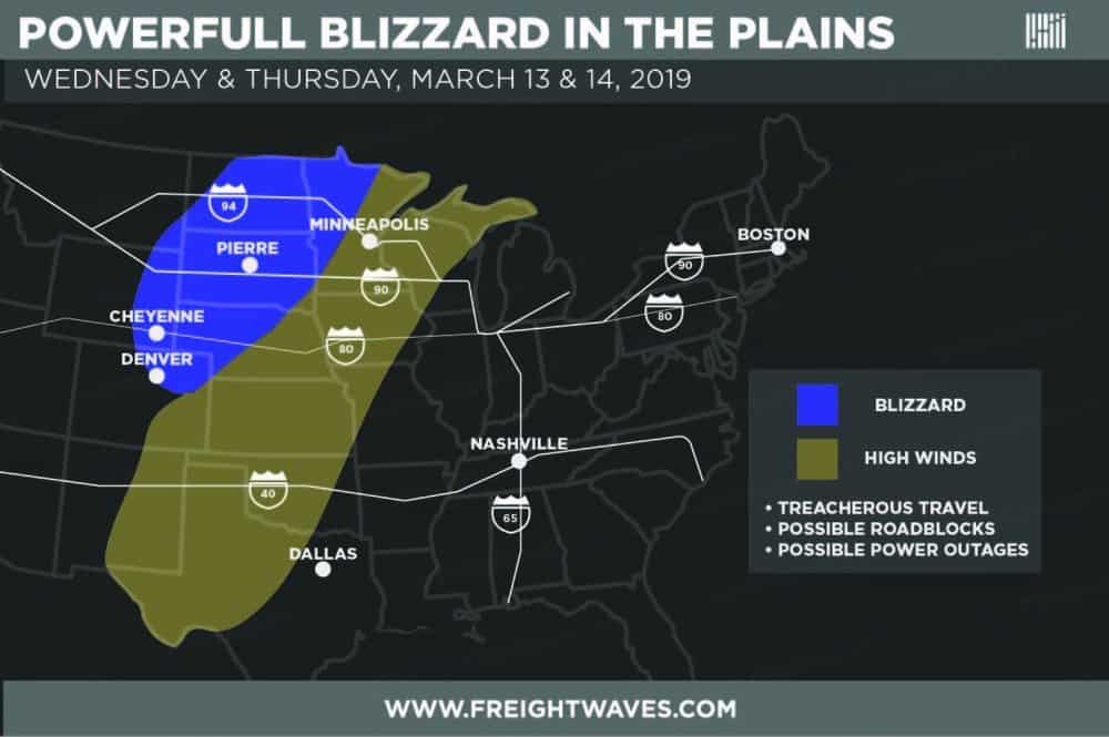
The atmospheric pressure in this blizzard could be very low for a non-tropical system. This will generate a gradient – change in pressure (in this case a decrease) over distance – strong enough to create wind gusts of 60 to 70 mph. These powerful winds will last for hours and hours in many areas, potentially blowing down trees and utility lines. People should prepare to stay put after the storm since roads may be blocked and widespread power outages are possible. The storm could also damage homes, businesses and other structures.
Fierce winds could extend hundreds of miles from the blizzard, to the warm side of the storm in the southern Great Plains. Travel will be difficult on the following routes:
• I-35 from Oklahoma City to Wichita
• I-40 from Oklahoma City to eastern New Mexico
• I-10 and I-20 from central and western Texas to eastern New Mexico
• I-27 in north Texas
In the Air
Commercial and freighter pilots will likely have to fly around the massive storm in order to keep passengers and cargo safe. Last week FreightWaves published an update about the Amazon cargo plane that crashed in Texas last month. Based on a preliminary report from the National Transportation Safety Board (NTSB) just released today, turbulence may have been a factor in that crash. Further investigation is needed to confirm this.
In any case, flights in and out of Denver, Cheyenne and other airports in the target zone of the impending blizzard could be delayed or canceled on Wednesday and Thursday. Check with your airlines before heading to your flight.
Look for more weather updates during the week on the FreightWaves website.
