


People in North Carolina need more rain like they need holes in their heads, but there’s more coming this weekend. It’s bad enough that a large part of the state was flooded by Hurricane Florence for weeks back in September, but more flooding is possible with this next round of downpours. It’s been a record year that people there probably want to forget.
Florence is the second-wettest tropical system to hit the U.S., behind Hurricane Harvey. Swainsboro, North Carolina had one of the top rain totals from the storm at 36.0 inches. An average of around 17.5 inches of rain fell over a period of a few days, as measured by five weather reporting stations covering 14,000 square miles from Fayetteville, North Carolina to Florence, South Carolina. This is according to preliminary calculations from Dr. Ken Kunkel, a climate extremes researcher from North Carolina State University.
Florence helped catapult Morehead City and Wilmington to annual rainfall records approaching 100 inches. The National Weather Service office in Newport-Morehead City (NWS code: MHX) has received 98.30 inches so far this year, breaking the previous annual rainfall record of 70.48 inches in 2014. The Wilmington International Airport (ICAO code: ILM) has measured 97.75 inches to date this year, breaking a 141-year-old record of 83.65 inches. Both records far exceed their annual averages of 55.4 inches.
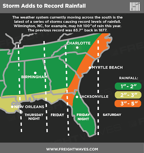
The rains coming Friday night and Saturday to eastern North Carolina and the Outer Banks could total two to four inches, with isolated spots of five inches. Casey Dail, a meteorologist with the National Weather Service office in Newport-Morehead City, tells FreightWaves that she’s concerned about flooding and rain totals for the year pushing past the 100 inch mark.
“Because of heavy rain last weekend, there’s still standing water in some areas, and rivers will rise more after the rain this weekend,” says Dail.
She’s most concerned about areas such as Kinston along the Neuse River which is at minor flood stage. It’s forecast to swell to moderate flood stage by early next week. Another problem area is Greenville along the Tar River which is forecast to reach minor flood levels by Sunday. Although widespread, long-term flooding isn’t likely, there’s a good chance for localized flash flooding in neighborhoods along these rivers.
Just a bit down the road to the south, people in Wilmington, as well as Georgetown and Myrtle Beach in South Carolina, could also get flooded. Inland areas are at risk, too. The following rivers in the region could be at minor or moderate flood levels by Sunday or Monday: Black River, Cape Fear River, Greater Pee Dee River, and Little Pee Dee River.
Two reasons for the excessive rainfall potential are the strong flow of tropical moisture off the Pacific Ocean and Gulf of Mexico, and the fairly slow-moving track of the system. Adding to the chance of heavy downpours will be isolated thunderstorms which could also produce gusty winds.
For truckers on I-10 and I-75 from Tallahassee to Lake City, and on I-95 near the southeast coast this means that, at times, torrential rain will make it hard to see the road and other vehicles ahead of them. They should take breaks during times of limited visibility and/or windy conditions that take them out of their comfort zones. Drivers might also run into roadblocks, especially where water ends up flooding secondary roads on their routes.
Flood Warning and Flash Flood Watches have been issued by the NWS. Updates can be found on this interactive map.
