


Old Man Winter isn’t done with the West this week. Snow has already been falling today in northern California, across the Cascades and the Sierra Nevada, as well as in the Cascades of Oregon. Much more is expected in the next few days, adding to the massive heaps of snow at the ski resorts, but making trouble for drivers.
Here and Now
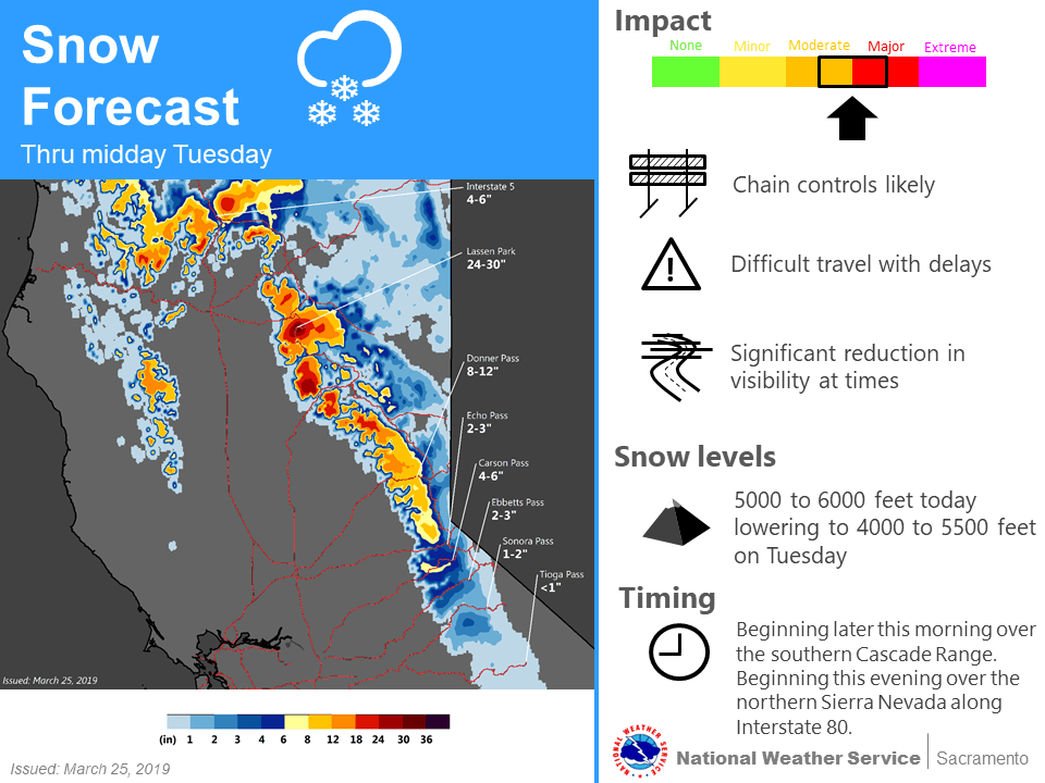 Short-term snowfall outlook, Monday through Tuesday morning, March 26. (Source: NOAA)
The first of two cold fronts this week is hitting the West Coast right now, producing heavy snow mainly in California through Tuesday morning. It will likely dump totals of 12 to 24 inches above 5,000 feet in elevation (with locally higher amounts) from western Plumas County to Lassen Volcanic National Park. Snowfall accumulations of an inch or two are possible down to 4,000 feet.
Some parts of Siskiyou County, above 4,000 feet, could see up to 16 inches of fresh snow, while lower slopes below 4,000 will likely receive two to six inches. Wind gusts of 40 to 50 mph will make travel even tougher, particularly through the following areas:
• Highway 89 at Snowmans Summit
• Mount Shasta Ski Park Highway
• Black Butte Summit on I-5
• Mount Shasta City
• US-97 around Tennant
• Sawyers Bar Road near Etna Summit
Snow will spread eastward later today and tonight across the west slope of the northern Sierra Nevada, where accumulations of four to eight inches will be common, with pockets of up to 12 inches. Typical trouble spots will be US-50 over Echo Summit, as well as I-80 over Donner Pass. Several inches of snow will cover roads, including CA-70 and CA-89, in eastern Plumas County and eastern Sierra County.
Looking Ahead
Snow will keep coming down Tuesday afternoon through Wednesday night in the northern Sierra Nevada as a second cold front comes in right behind the first one. However, snow will also develop in the southern part of the mountain range, leading to potential road closures.
In Eastern Plumas and Sierra counties, look for additional snow accumulations of 10 to 20 inches west of US-395, and four to eight inches above 5,000 feet elsewhere. Lighter amounts up to two inches are possible down to valley floors by Wednesday evening. Winds gusts will reach 50 mph on the highest peaks.
Other areas in the target zone are from Yosemite to Kings Canyon National Park, including Camp Nelson and the Tulare County Mountains. Total snow accumulations of 12 to 24 inches are a good bet above 5,000 feet, with isolated spots of up to 36 inches possible along the crest. Powerful gusts could reach 65 mph on exposed ridgetops and near the crest.
Mono County, including Mammoth Lakes and Mammoth Mountain, could get slammed with eight to 16 inches of snow, and up to 22 inches along the crest. Dangerous winds could gust as high as 80 mph across Sierra ridges, and up to 40 mph in valley locations. Mammoth Mountain has already received an incredible 54 feet of snow this winter, and other resorts in the region are having stellar seasons, too.

Various winter weather alerts have been issued by the National Weather Service (NWS) for eastern California, and more may be added later today or tonight. Updates can be found on this interactive map, and check chain laws here for the latest updates on winter driving.
Look for more weather updates throughout the week on the FreightWaves website.
