


The blizzard that broke low pressure and wind records across the Great Plains on Wednesday and Thursday is finally fading as it exits the U.S., heading into eastern Canada. The storm only lasted for a couple of days, but memories of it will probably linger for years to come in the memories of everyone in its path. The heavy snow and ferociously high winds led to whiteout conditions, followed by a chain reaction of Interstate shutdowns, airport closures, automobile wrecks, power outages and at least one death.
Looking Back
The worst of the storm targeted eastern portions of Colorado and Wyoming on Wednesday, in addition to western sections of Nebraska where more than 12 inches of snow fell in some spots. Blowing and drifting snow resulted in snow banks several feet high. It got so bad that Colorado Governor Jared Polis sent the National Guard to help rescue drivers who were stranded on closed roads. These are a few snow/wind reports from Wednesday:
• Cheyenne Regional Airport: 14.0 inches/63 mph
• Scottsbluff-Western Nebraska Regional Airport: 12.0 inches/65 mph
• Denver International Airport: 7.1 inches/80 mph (all-time record gust)
Another record wind gust, 96 mph, was reported at the Colorado Springs Municipal Airport. The storm “bombed out” over this region when the central pressure dropped 33 millibars in a 24-hour period, between 9:00 a.m. MDT on Tuesday and 9:00 a.m. MDT on Wednesday. This created the powerful winds, and so far the lowest pressure measured in the storm was 970.4 millibars in Lamar, Colorado. This is only 10 millibars away from the lowest pressure reading during the “Blizzard of ‘93” – 960 millibars – which also occurred in mid-March.
Trouble Ahead
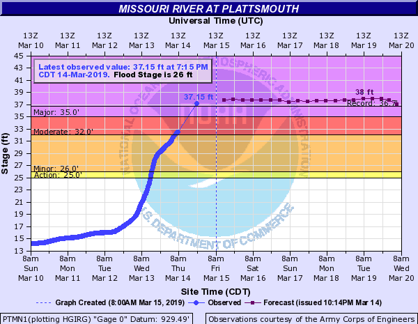

On the other side of the storm, heavy rain and snowmelt caused rivers and creeks to rise rapidly across the Midwest on Thursday. The Platte and Missouri Rivers reached record flood levels in the Omaha, Nebraska area, washing out roads and at least one bridge. Areas along the Elkhorn River are also experiencing historic flooding.

Near the town of Columbus, flood water covered streets and has risen almost to the tops of road signs. In Nickerson, the local Volunteer Fire Department performed two rescues of people from flooding along Maple Creek on Thursday. Finally, a tractor-trailer got stuck in flood water near Bell Creek in Arlington. Neighborhoods along the North Platte River near I-80 are also flooded. Reports of flooding, as well as mud and debris across roads, have come in from Iowa and Minnesota, too.
According to state Departments of Transportation, many secondary roads are closed in parts of Iowa, Minnesota, Missouri, and Nebraska because of flooding. Some rivers and creeks may not recede below flood their flood stages until the middle of next week, or later. In the coming days, the risk of flooding may move downstream to the Kansas City and St. Louis areas, closing more roads and delaying barge traffic.
Submerged truck by Bell Creek flooding in Arlington. @3NewsNowOmaha pic.twitter.com/Zto5hMi3Rn
— Wade Lux (@WadeLux) March 14, 2019
Nobody, including truckers, should try to drive or walk through flood waters. They may be deeper than you think, and the road could be washed out underneath. For the latest flood alerts from the National Weather Service, check out this interactive map. Please, be careful out there!
