


A monster snowstorm is cutting a path through the Rockies right now, setting its sights on the Midwest for the weekend. Massive amounts of snow and extremely brisk winds will likely disrupt freight movement, and will probably put a stop to recreational outdoor plans.
Rocky Mountain High?
A low pressure system is spinning out west, dumping heavy snow across parts of the Rockies. This includes western Colorado where the threat for more avalanches is high. Gusty winds are also making travel difficult across the region, blowing snow around and reducing visibility. Even though the storm will fade later tonight into early Saturday, most, if not all interstates across the Rockies will remain snow-covered and treacherous through the weekend.
Snowbound Saturday
The storm blasts into the Midwest on Saturday, burying many towns in the Dakotas, northern Nebraska and Michigan’s Upper Peninsula. Minneapolis-Saint Paul is the largest metropolitan area that will take the brunt of the storm, along with the nearby cities of Saint Cloud, Minnesota and Eau Claire, Wisconsin. These cities have already seen four to six inches of snow this month. The approaching blizzard will produce up to 12 additional inches in some neighborhoods, which, itself, is more than an average March snowfall for these areas.
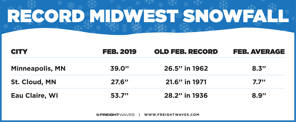
Current snow depths in the aforementioned cities range from 18 to 21 inches – this is what is still on the ground. It’s been an epic winter with record-setting February snowfalls, according to National Weather Service (NWS) records.
Snowfall rates of one to two inches per hour will make it hard enough for truckers who can’t avoid hauling through the Midwest this weekend. However, as is the case with blizzards, snowfall only tells half the story. Gusty winds reaching 45 mph will blow the snow around in many areas, resulting in reduced visibility and difficulty deadheading. Whiteout conditions probably won’t be widespread across the region, but could happen in localized spots. Blizzard conditions are also possible across Michigan’s Upper Peninsula, including Marquette, and northern sections of lower Michigan (mostly north of Lansing).
Northeast Nuisance
The Midwest snow will fade gradually on Sunday, but winds will keep whipping across the region. The heaviest snow on Sunday will trek through the Northeast, from upstate New York to Maine. Winds won’t be as strong in these areas compared to the Midwest, with the exception of cities downwind from Lakes Erie and Ontario.
Powerful gusts up to 60 mph will make driving extremely unpleasant and dangerous on I-86 and I-90 in upstate New York. Areas of particular concern are Buffalo, Jamestown, Niagara Falls, Rochester and Watertown. The storm will finally loosen its grip on the U.S. late Monday as it moves into Canada’s Maritime provinces.
Check chain laws here for the latest updates on winter driving, and look for the latest winter weather alerts on this interactive map.

Other Significant Weekend Weather
On the southern end of the blizzard where the air will be much warmer, thunderstorms are a good bet across portions of the Mississippi and Tennessee River valleys on Saturday. Rain totals of one to three inches will be common, including in areas of Tennessee that are still flooded from recent heavy rains.
Some of the storms could become severe, producing torrential downpours, as well as very gusty winds, hail and possibly isolated tornadoes. The target zone for the worst storms could be from the Memphis metro area to southern Illinois, but this may change. Updated severe weather outlooks can be found here.
Please be careful and have a safe weekend!
