


Another storm taking shape in the southwestern U.S. will gain momentum soon, making for a wintry weekend for millions of people in the nation’s heartland and the South. An area snowed in by a major storm early last month will be one of the target areas. For others, it will be the first significant snowfall of the season. Carriers will want to plan ahead, and drivers will have to be extra careful.
Friday Afternoon Through Saturday
The system will pump plenty of moisture from the central Great Plains to the mid-Atlantic through the duration of the storm. Precipitation will start as rain, but then a very cold air mass will settle into these areas, changing the rain to snow and freezing rain.
It will really crank up Friday afternoon and Friday night, spreading a swath of snow through the day on Saturday from Kansas all the way to western Ohio, stretching as far north as Chicago and as far south as northern Kentucky. Some of the heaviest snow will fall from near Kansas City over to St. Louis and Indianapolis, along the I-64 and I-70 corridors, where totals could reach close to 10 inches. Winter Storm Warnings has been issued by the National Weather Service (NWS) for several areas.
This will be the first major snowfall of the season for St. Louis. Patrick Walsh, a meteorologist there with the NWS, tells FreightWaves that the city got two early-season doses of snow in November, each totaling two to three inches. But this weekend’s storm would be the first since 2014 to produce six inches or more.
On the southern side of the storm, freezing rain and icy conditions will develop for a period of time Friday afternoon along the Arkansas-Missouri border and Friday night along the Kentucky-Tennessee border near Nashville. This will turn to just rain on Saturday as temperatures in these areas warm above freezing.
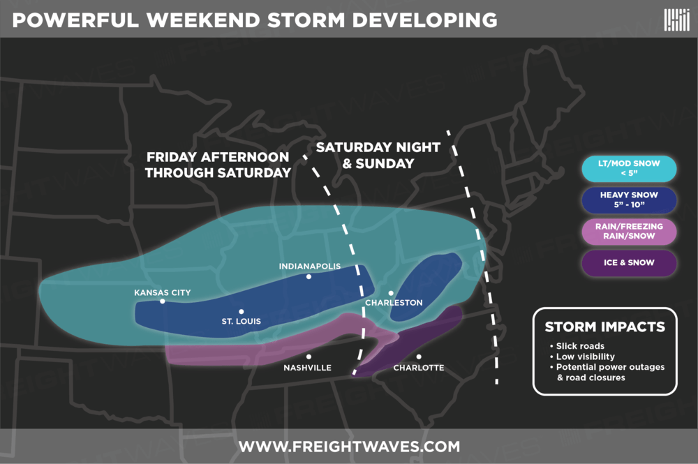
Saturday Night and Sunday
The storm will fade in places previously mentioned. For the rest of the weekend the snow will shift to areas east of the Ohio River Valley. Two to five inches of snow will be common in eastern Ohio and eastern Kentucky, as well as West Virginia, Virginia, and western North Carolina. The two exceptions, where 10 inches of snow could accumulate, are the Allegheny Mountains straddling the Virginia-West Virginia border and pockets of the Appalachians in western North Carolina.
Unfortunately, freezing rain and icy conditions could develop in the mountains of western North Carolina prior to the snow, making for very treacherous travel. This region was snowed in by Winter Storm Diego in early December and will have to prepare for another big blow from Old Man Winter this weekend. The storm will finally start to lose steam by Sunday night, but high temperatures on Monday won’t escape the 30s for much of the area. It may get warm enough for some melting by Tuesday.
Storm Impacts
Ice, as well as heavy, wet snow could weigh down large tree limbs and electrical lines in some areas. Freezing rain will lead to iced-over roads, bridges, and overpasses. Also, some areas will experience strong winds and blowing snow. Drivers – get ready for any of the following to delay your deliveries if you can’t beat the storm or find another route:
Slick Roads
Low Visibility
Possible Power Outages and Road Closures
Please stay safe out there! Check chain laws here for the latest updates on winter driving, and use this interactive map for updated winter weather alerts from the NWS.
