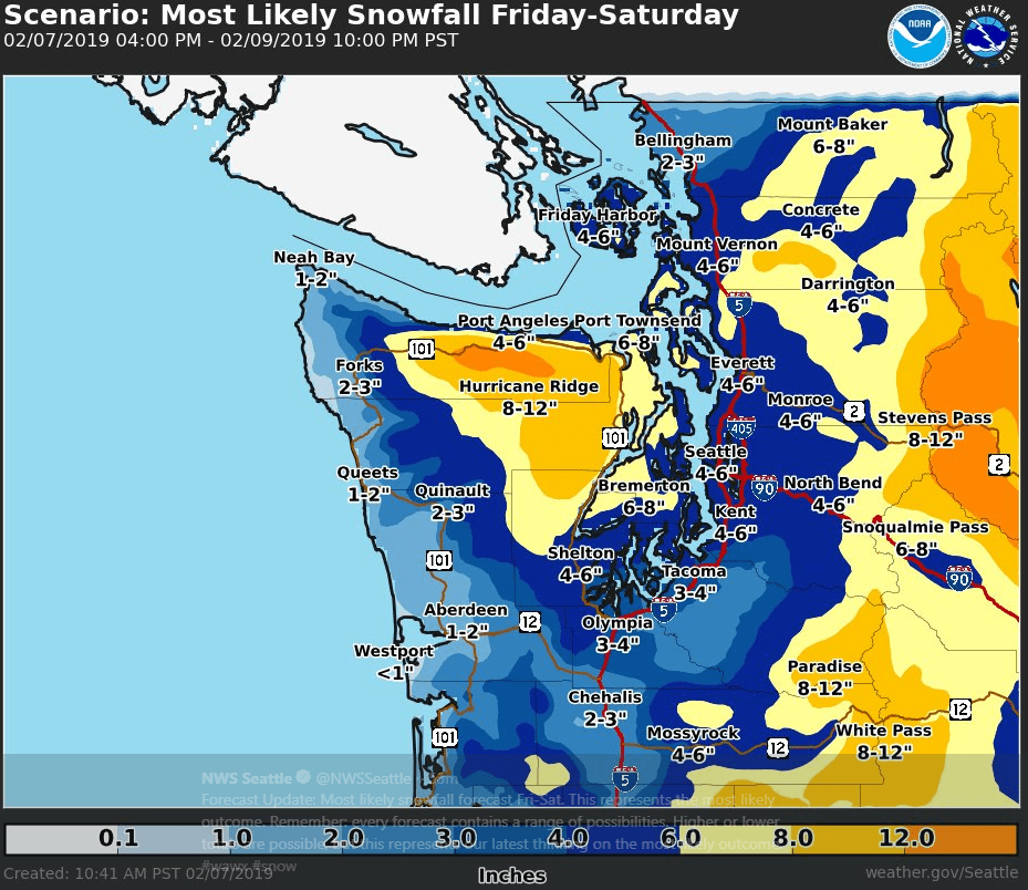
Many eyes in the weather world are focusing on the northwest corner of the U.S. A storm of significant proportions is about to turn the Pacific Northwest into a winter wonderland this weekend, much to the joy of children (and some adults) who enjoy skiing and sledding, but to the chagrin of truck drivers. We’re not talking historical snowfall amounts here, but travel troubles are a good bet because a decent amount of snow may cover lower elevations, including Seattle.
Development and Timing
A strong low pressure system over the Northwest Territories of Canada will bring another surge of arctic air across the interior of British Columbia tonight (Thursday) into Friday, heading down the Fraser River Valley late on Friday. At the same time, cold air and moisture will work eastward into Washington State across the Olympic Range and Puget Sound. This will be a favorable set-up for potentially large snowfall amounts across the region.
Most of the area will be dry Friday morning, except for some light snow in Whatcom County along the Canadian border. Snow will pick up in intensity a bit through the day Friday, spreading southward, reaching the Seattle metro area (around 430 feet above sea level) during the 12:00 to 4:00 p.m. PST time frame. This could make for a messy commute as people try to get home for the weekend. But the heaviest snowfall will likely happen Friday night and Saturday morning, fading Saturday afternoon and evening.
Snowfall Amounts

A wide swath of eight- to 12-inch storm totals is forecast over the Olympics (just west of Puget Sound), while a few areas along US-101 in Clallam County could get more than 12 inches. Other areas along the I-5 corridor – Everett, Olympia, Tacoma and Seattle – may see three to six inches. Even coastal and inland communities on US-101 could see a few inches!
These projected amounts are significant, but not record-breaking. As a matter of fact, if Seattle-Tacoma International Airport (ICAO code: SEA) manages to officially get six inches, this wouldn’t come close to making the top 10 list of two-day snow totals for the area. But meteorologist Gary Schneider with the National Weather Service (NWS) office in Seattle told FreightWaves that the storm’s impacts could be disruptive to travel. Schneider also mentioned that snowstorms of this magnitude have happened less and less frequently during the past few decades, but they still pop up every few years or so, making things interesting.
There’s one thing to keep in mind – this represents the most likely outcome from this two-day event. Every forecast contains a range of possibilities, and higher or lower totals are possible. The best advice for people is to prepare for the worst case scenario by staying off snow-covered roads as much as possible.
There’s also a good chance of heavy snow (eight to 12 inches) in the Cascades of central Washington State, including Stevens Pass, with several inches possible on portions of I-90 from Moses Lake to Spokane in eastern Washington.
Wind and Cold
The snow will be paired with strong winds that can cut right through you. Gusting will reach 40 mph across Puget Sound, and up to 60 mph to the north, resulting in uncomfortably cold conditions. Temperatures will drop into the 20s on Saturday, remaining there all day. Drivers will need to bundle up and make sure they have enough winter additive in their diesel in order to prevent fuel gelling. Lows will fall into the teens Saturday night. Wind damage and power outages are possible, so everyone should have flashlights ready with fresh batteries in them.
Impact on Freight
Looking at the latest FreightWaves SONAR data on the map directly above, outbound volumes lately in the Pacific Northwest – Pendleton, Portland, Seattle and Spokane markets – have been stagnant (white-shaded) or decreasing (red-shaded). These markets are typically busiest in the fall during apple and Christmas tree picking seasons. So, the main impacts of the weekend snowstorm will be on the safety of any drivers who may have to haul through this region. Roads will be quite slick, and visibility will be reduced at times due to blowing snow. The latest chain laws can be found here, and winter weather alerts from the NWS are on this interactive map. Please be careful out there!


