


The lake effect snow machine will show no mercy this weekend across western New York – mainly the Tug Hill region – as well as northern Michigan. Strong winds in these areas will add to the misery, as some people might perceive the situation, making it risky and unhealthy to be outside for more than a few minutes.
Big Dose of Snow
In New York, areas along I-81 from Oswego to Watertown could get buried under 16 to 24 inches of new snow through early Saturday in the most persistent snow bands, as well as along State Route 26 through Lowville. An additional eight to 14 inches could pile up along the I-90 corridor from Buffalo to Batavia, as well as from Jamestown to Orchard Park. Occasional snow showers may linger on Sunday, but additional accumulations will pale in comparison to the day before. The National Weather Service (NWS) has issued Winter Storm Warnings for these areas.
Snowfall won’t be as aggressive in the Upper Peninsula (UP) of Michigan, but totals in some towns won’t be anything to sneeze at. Through the day on Saturday, another six to 10 inches could accumulate north of Houghton on the Keweenaw Peninsula, but areas just to the south and east of Houghton will probably be spared from the heavier snow. Other spots like Newberry and Ontonagon could see a few more inches, too.
Check chain laws here for the latest updates on winter driving.
Harsh Winds and Bitter Cold
Along with the snow and wind, the air will be bitterly cold all weekend across the Great Lakes states, with wind chills of 25 degrees below zero or lower by sunrise on Saturday. The worst conditions will be across the Arrowhead of Minnesota, northern Wisconsin, and Michigan’s UP, where wind chills could dip to minus 40 degrees. For trucks parked overnight, there’s a potential for brake failures, fuel gelling, and/or trouble starting due to aging batteries with low Cold Cranking Amps (CCA) values. Drivers: plan for delays and possible road closures, and if your loads are “protect from freeze,” make sure they’re hauled on reefers with the temperature set properly.

Also, in these harsh conditions, frostbite of exposed skin can happen within 10 to 15 minutes. The best ways to stay safe are to dress in layers, wear hats and gloves, and simply limit the amount of time outside.
Crosswinds gusting to 35 or 40 mph will make it difficult for drivers deadheading or hauling light loads through the areas previously mentioned, and blowing snow could occasionally limit visibility to zero.
In addition to possible problems for truckers, anyone bringing boats to dock or ships into port along the shores of Lakes Michigan and Superior need to know that rapid ice accumulation is likely on their vessels this weekend due to freezing spray. This can be extremely hazardous to navigation. Details on the Heavy Freezing Spray Warning and Wind Chill Warnings can be found on this interactive map.
Impact on Freight Movement
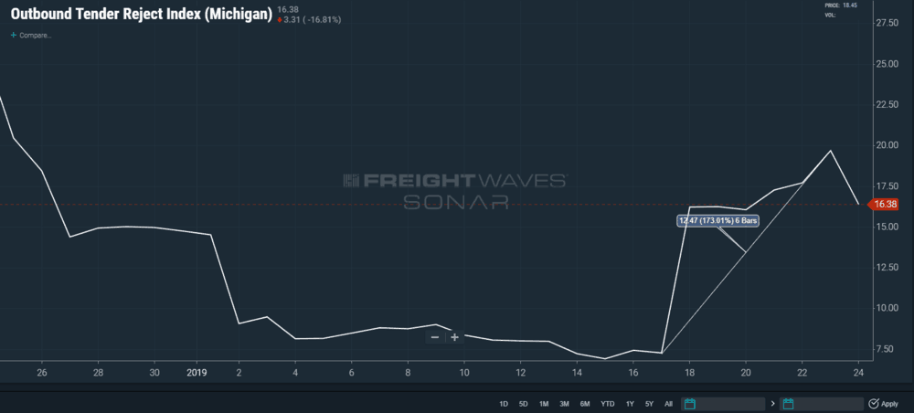
Looking at Michigan, recent outbound tender rejections more than doubled in less than a week. This was likely due to record snowfall in some parts of the state last weekend, as there wasn’t a significant increase in outbound volume causing carriers to reject loads. With more heavy lake effect snow this weekend, tender rejections may remain elevated in the coming days.
