


“Water, water everywhere, nor any drop to drink.” The famous line from Samuel Taylor Coleridge’s epic poem The Rime of the Ancient Mariner is a metaphor for not benefiting from something, despite being surrounded by it. In the case of the ongoing floods in the Midwest, the line can be taken literally.

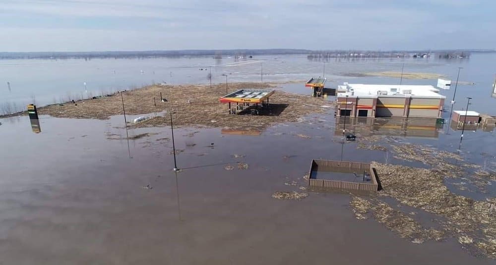
The region was hit by a major storm on March 15, 2019, followed the next day by the commencement of record flooding due to a disastrous combinations of heavy rain, snow melt and ice jams. Most of the damage was along the Missouri River in eastern Nebraska and western Iowa, costing an estimated $3 billion, so far, based on the latest estimates from state officials. Around $1 billion of the total damages were agricultural losses. Farms and cattle ranches were among the thousands of homes and businesses destroyed.
The National Weather Service (NWS) office in Omaha, Nebraska has 265 river gauges in its area of responsibility, and 40 of these gauges were still above flood stage as of this afternoon (Wednesday, March 27), 12 days after the flooding began. Around a dozen of the flooded gauges are along the Missouri River, with one at major flood stage at Miami, Missouri. Five others also remain at major flood stage – two on the James River (South Dakota), two on the Big Sioux River (Iowa), and one on the west fork of the Des Moines River (Iowa). The remaining locations are at moderate or minor flood levels on the rivers previously mentioned, as well as other rivers in the region, including the Platte.
Also, 10 to 20 inches of snowpack still cover the ground on either side of the Missouri River from North Dakota into South Dakota. Much of this has become water today because of abnormally warm temperatures in the 60s. The only way the snowmelt can flow is downstream toward Nebraska, Iowa and Missouri. The excess runoff will continue to keep water levels high for at least another week in some cases.
Two other factors may add to the chances of floodwaters wearing out their welcome – ice jams and precipitation. First, any large chunks of ice that are still floating in previously frozen rivers could block the flow of water. This would happen primarily in the Dakotas. Second, periods of heavy rain are possible across the flooded areas over the next several days, particularly from Omaha southward on Thursday and Friday. Even if this doesn’t make the situation worse, it’ll keep it steady.
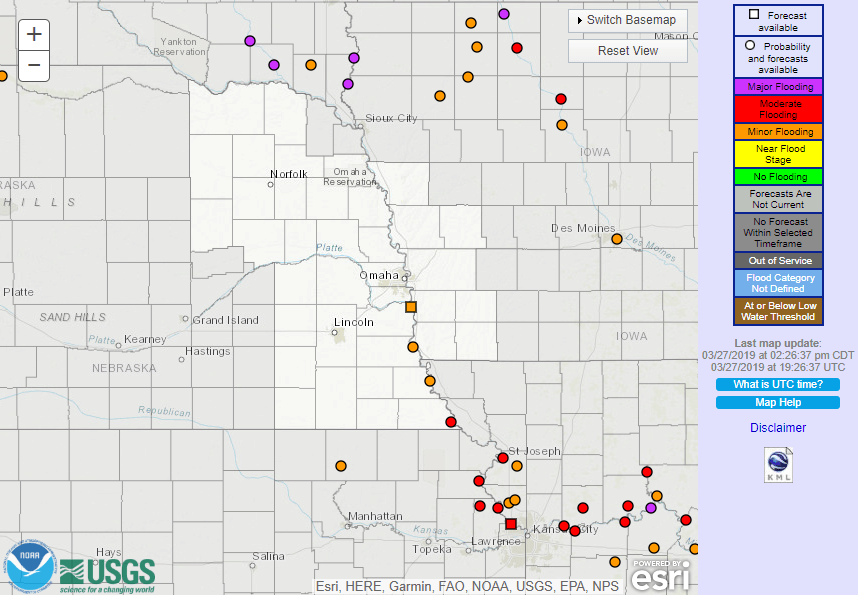
Flood Warnings have been posted by the NWS practically non-stop since the storm hit, and they will likely be updated and new ones possibly added in the coming days. Updates can be found on this interactive map. Also, look for more weather updates on the FreightWaves website.