


A developing storm in the Great Plains is going to make a mess of things for the next couple days across a pretty large part of the U.S. Slushy, icy conditions will make travel difficult in many areas, but downright impossible in others. Drivers who can’t get around the winter weather will have to plan ahead for delays.
Snow
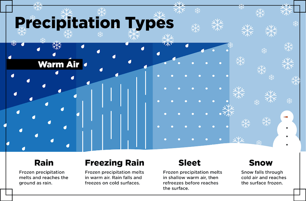
Winds off the Gulf of Mexico are sending plenty of moisture into the eastern half of the country, with a lot of cold air in place across the Midwest, Northeast, and parts of the Southeast. Snow will fall where temperatures are at or below freezing throughout the entire atmosphere. In other areas, sleet or freezing rain will develop where milder air aloft glides over colder, dense air at the surface.
The heaviest snow has been developing today (Tuesday, February 19) across portions of northern Texas, and will continue to spread into Oklahoma City and central Kansas along I-35. This will linger into the evening, with up to six inches of accumulation; but look for locally higher amounts here and there. The snow will then move northeastward, hitting cities like Topeka, Des Moines and Saint Louis overnight. Then late tonight into early Wednesday it’s off to Chicago, Cincinnati, Columbus, Indianapolis, Pittsburgh and Washington, D.C., making for a very messy morning commute.
Several inches of overnight snow will also fall in the Shenandoah Mountains of Virginia and West Virginia. The snow won’t let up much on Wednesday morning as it moves through eastern Pennsylvania (including Philadelphia), then toward New York City and Boston during the afternoon and evening, turning I-95 into a possible nightmare.
Ice

For many of the areas previously mentioned, the snow may change to sleet for a while, or worse yet, freezing rain. Some areas of the Northeast could see the worst conditions, with ice accumulations a quarter-inch to a half-inch along parts of the I-81 corridor in the Appalachians. Winds could be strong enough to blow down large tree limbs and power lines in some areas, possibly blocking routes and knocking out electricity. In other areas, tree limbs and power lines could simply buckle under the weight of the ice.
Winter Storm Warnings and Winter Weather Advisories have been issued by the National Weather Service (NWS) and are continually updated.
Impact on Freight

This won’t be a catastrophic, long-term event, but it could cause short-disruptions in some freight markets. Inbound volume has been declining in many markets that are in the path of this storm (green box on the map directly above). However, FreightWaves SONAR data shows decent outbound volumes (blue-shaded) in some of these markets. So, getting more loads out of these areas could be difficult for the next day or two as some trucks may get stuck in the ice or snow. Several major interstate routes will be affected by this storm, so drivers will need to be extra careful. Expect delays due to worsening road conditions, slow traffic and potential roadblocks.
