


As FreightWaves mentioned yesterday, a snowstorm of massive proportions is going to slam the Sierras soon, mostly in northern California. It’s still on track to dump extremely large amounts of snow and whip up very powerful winds from this evening through Thursday morning, but the forecast looks even worse than before. Blizzard Warnings have been issued by the National Weather Service (NWS) for the areas described in the following sections. Here’s an update on expected conditions.
Western Plumas County, Lassen Volcanic National Park, West slope of the northern Sierra Nevada
Snowfall accumulations of two to four feet are likely above 5,500 feet, with local accumulations up to six feet over the peaks, and blizzard conditions above 6,500. Wind gusts could reach 60 mph or higher, making travel that much more dangerous on state routes 36 and 89.
Mono County, including the cities of Bridgeport, Coleville, and Mammoth Lakes
Heavy snowfall accumulations of two to five feet will be common west of US-395 above 7,000 feet, with 10 to 20 inches elsewhere above 7,000 feet, along with blizzard conditions. Winds could gust to an astonishing 125 mph on the tallest ridge tops.
Greater Lake Tahoe Area, including the cities of Incline Village, South Lake Tahoe, Stateline, and Truckee
Heavy snow accumulations of two to five feet will bury elevations above 7,000 feet, with blizzard conditions expected. Between 6,000 and 7,000 feet snowfall of 12 to 24 inches could pile up. Wind gusts could reach staggering levels of 90 to 130 mph on the highest peaks and ridge tops.
It will be risky for drivers to go through most of these areas, or simply impossible, and many mountain passes could be closed for several hours so that snow can be cleared. Delays are inevitable.
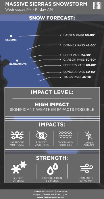
The combination of wind and heavy, wet snow could blow down trees and power lines, knocking out electricity and potentially blocking roads. White-out conditions will reduce visibility to zero in many spots. Also, heavy rain in the foothills of the northern Sierras could cause flooding, mudslides, and debris flows from wildfire burn scar areas, all of which could cut off routes.
The storm will gradually fade through the day on Thursday, but roads will likely remain treacherous for days, possibly including I-80 through Reno. Drivers will probably have to find other routes.