


Overview
A storm that has been dumping rain and mountain snow in the Southwestern U.S. will slam the South Central and Southeastern U.S. with ice, heavy snow, and potential floods this weekend. It will rapidly strengthen and could turn out to be a crippling event on the wintry side of the storm, leading to travel delays and cancellations, as well as disruptions in regional supply chains.
Analysis and Timing
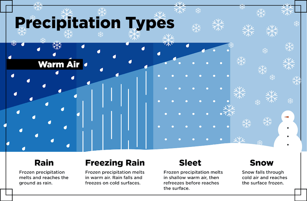
As Pacific moisture feeds into colder air on the northern side of the storm, treacherous conditions could develop from the Texas Panhandle eastward to the Carolinas from Friday through Sunday. At first the precipitation might fall as sleet or a mix of sleet and snow, or as more dangerous freezing rain which is rain that freezes on contact with the ground and other surfaces.
In such a scenario, temperatures on the ground are at or below freezing while temperatures aloft are above freezing. When temperature increases with altitude, as in this case, it’s called an inversion. As rain falls through the deep layer of warm air aloft onto freezing surfaces below, everything ices over. This is illustrated in the graphic below:
The latest outlooks show some areas will receive a quarter to a half an inch of ice accumulation from Amarillo, Texas eastward to near Oklahoma City, northern Arkansas, southern Missouri, southern Kentucky, and northwestern Tennessee. Several inches of snow will then pile up on top of the ice in many of the areas previously mentioned, adding insult to injury. Large tree limbs and power lines will buckle under the weight of the snow and ice, potentially knocking out electricity to a fairly large portion of the country.
The map below is an approximation of timing and location of precipitation types for this storm. This is a complex system, so adjustments will likely be made as the storm evolves.

Impact on travel and the supply chain
Charlotte looks to be the largest metro area – estimated at nearly two and half million people – that will be most severely impacted. Up to six inches of snow are forecast for the city, with ten inches or more in the high elevations north of I-40. This could be preceded by ice. A storm of this magnitude might effectively shut down the city for at least a few days.
Shippers who are sitting on orders until next week but have them ready to go should send them as soon as possible. Charlotte has become an increasingly acute backhaul market in recent weeks, meaning more trucks have been entering versus leaving. This is indicated by the red shading in the Charlotte area on the map below. There should be plenty of capacity to get your shipments trucked out of the area before the storm hits by Saturday night and Sunday.

Air freight into and out of Charlotte will likely be disrupted, and travelers will need to check commercial flights. Many of them could end up delayed or cancelled.
Lots of snow could also fall in the smoky Mountains of eastern Tennessee, making travel difficult on portions of I-40 and I-81.
Stay ahead of the storm
The National Weather Service will likely issue the following alerts as the winter storm develops:
-
Winter Weather Advisory: Be aware! Winter Weather Advisories are issued when snow, blowing snow, ice, and/or sleet are expected but conditions should not be hazardous enough to meet warning criteria. Be prepared for winter driving conditions and possible travel difficulties.
-
Winter Storm Watch: Be prepared! Winter Storm Watches are issued when conditions are favorable for a significant winter storm event – heavy sleet, heavy snow, ice storm, heavy snow, blowing snow, or a combination of events.
-
Winter Storm Warning: Take action! Winter Storm Warnings are issued for a significant winter weather event including snow, ice, sleet, and/or blowing snow. Travel will become difficult or impossible. Delay your travel plans until conditions improve.
Look for updates on this interactive map.
Warm side of the storm
Watch out for heavy rain, thunderstorms, and potential flooding for portions of Texas between Dallas and Houston, and along the Gulf Coast on the I-10 corridor across northern Florida, southern Georgia, southern Louisiana, southern Mississippi, as well as eastern South Carolina. Three to six inches of rain are possible in these areas. It’ll also be slow going at times on portions I-16, I-65, I-75, and I-95.
