


Two regions of interest this week for truckers will be the Mountain Prairie and the Southwest as the jet stream dips southward, sending a strong cold front across the eastern two thirds of the country. Also, the West region will be windy.
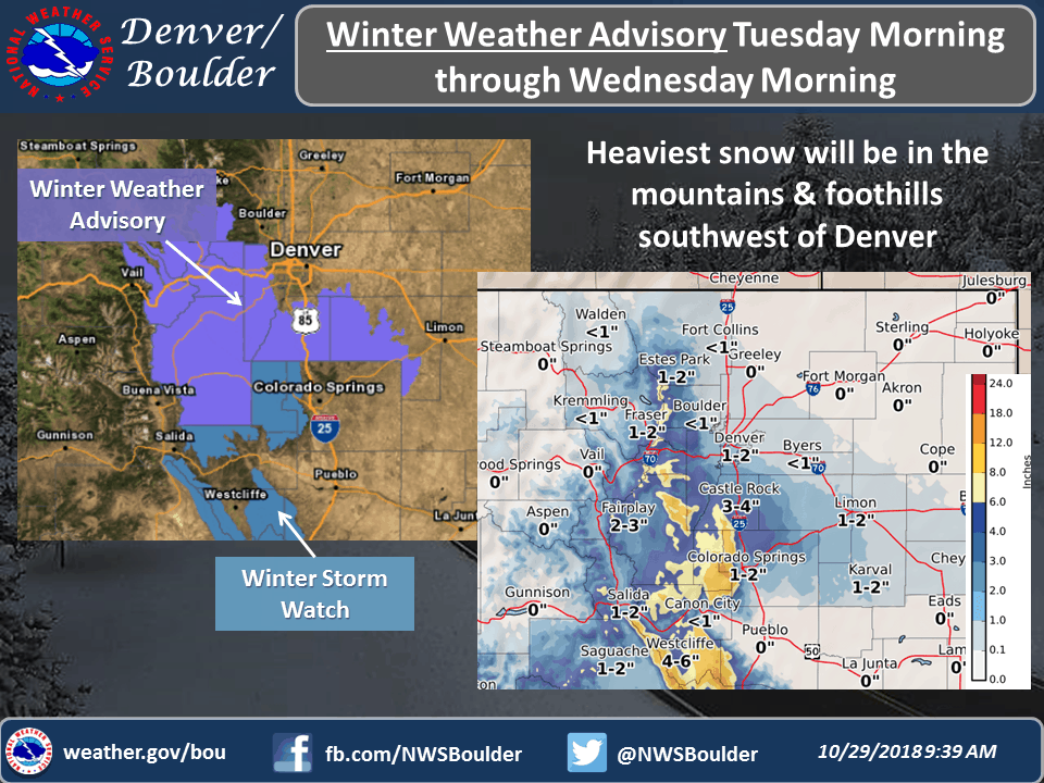
Heavy snow is in the forecast for the Rocky Mountains of Colorado from late tonight through Tuesday. You’ll need to get the chains on your tires and plan for slippery conditions, as well as getting loads out ahead of time.
Total snow accumulations of 4 to 8 inches are expected over the mountains east of the Continental Divide and south of I-70. West of the Continental Divide the snow will be lighter, 1 to 4 inches. This will mostly affect routes through Berthoud Pass, Breckenridge, the east slopes of the Mosquito Range, the east slopes of the Southern Gore Range, the Eisenhower Tunnel, Indian Peaks, Kenosha Mountains, Mount Evans, Williams Fork Mountains, and Winter Park.
Bigger snow totals are possible in other areas. Total accumulations of 6 to 12 inches could fall, with locally higher amounts, on east facing slopes of the Northern Sangre de Cristo Mountains between 8,500 and 11,000 feet, the Northern Sangre de Cristo Mountains above 11,000 feet, the Southern Sangre de Cristo Mountains between 7,500 and 11,000 feet, the Southern Sangre de Cristo Mountains above 11,000 feet, the Wet Mountains between 6,300 and 10,000 feet, and the Wet Mountains above 10,000 Feet.
The National Weather Service has issued Winter Weather Advisories and Winter Storm Watches for the areas listed above for Tuesday through Tuesday night.
The same cold front producing the snow will drop soaking rains from Texas to the Northeast on Wednesday and Thursday. Totals of three to five inches are possible in some areas. There’s also potential for severe thunderstorms across central and east Texas during this time. The downpours from these storms could be torrential at times, and might force drivers to slow down or time their rest breaks to coincide with periods of reduced visibility. This will mainly affect hauling of freight on I-10 and I-35.
Blustery conditions will be a challenge for truckers in the West region tonight and Tuesday. This will impact interior portions of northern California, including the Sacramento metro area. Winds of 15 to 25 mph will be common with gusts up to 35 mph. This will be especially difficult for anyone deadheading or hauling light loads. Major routes affected will be the 505, I-80, and the 5 from Redding to Modesto.
Because of extremely dry air combined with the strong winds, there’s also an elevated risk for wildfires in the region described above. Any fires that start could spread quickly, producing smoke and low visibility.