


It’s been a busy year so far for cyclones in the Southern Hemisphere. Australia has been hit by two major storms this March, Trevor and Veronica, that suspended dry bulk shipping around the northern coasts of the country. The world’s two largest dry bulk ports – Hedland and Dampier – are located there, and were still shut down as March 25, 2019. The two large, strong cyclones struck back-to-back in a short period of time. Major liquefied natural gas export facilities along the northwestern Australian coast have also suspended operations. All of this happening about a month before the official end of Australia’s cyclone season.
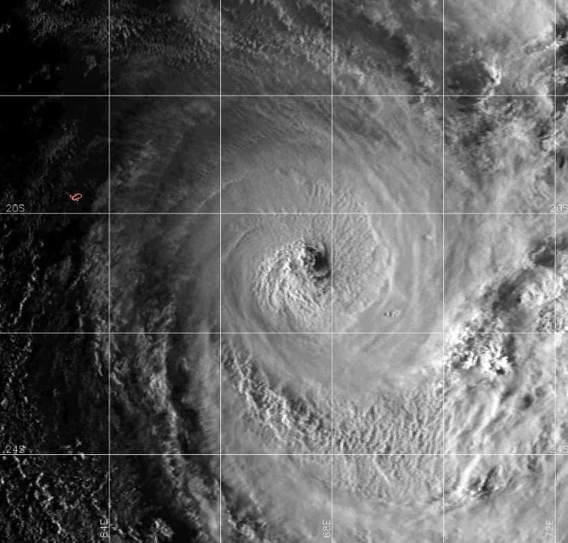
Another area south of the equator that has had recent run-ins with cyclones is the island of Rodrigues in the Indian Ocean. Tropical Cyclone Joaninha came close to making a direct hit earlier this week, and continues to linger nearby as of this evening (Thursday, March 28), local time (EDT plus eight hours).
As the storm slid past, strong winds and heavy rain slammed the tiny volcanic island located about 1,000 miles east of Madagascar. At its closest point, the eye of the storm was only 50 miles from Rodrigues, which is home to about 40,000 people.
Joaninha trudged along, moving at a sluggish 10 mph, ensuring a drawn out onslaught from the cyclone. Winds in Rodrigues’ capital of Port Mathurin, on the north coast, gusted over 60 mph (Tropical Storm strength) for more than 30 hours. The highest recorded gust anywhere on the island was around 100 mph (Category 2 Hurricane strength).
Some parts of Rodrigues reported nearly eight inches of rainfall from Joaninha, but the situation would have been even worse if the eye of the storm had made landfall. Gusts at the center of the cyclone reached 155 mph, the same speed as Hurricane Michael’s winds at landfall on the Florida Panhandle in October 2018.
Some people say “lightning doesn’t strike twice,” but this is the second storm to hit Rodrigues this year. Cyclone Gelena, a storm of similar size and strength as Joaninha, passed by the island in early February. It destroyed 90 percent of its electric grid, and forced the evacuation of more than 140 people to shelters. Most of the damage was due to fallen trees that led to blocked roads; there were also snapped power cables, telephone lines and widespread flooding was reported. Gelena caused around $1 million in damages.
This is an early start for the tropical cyclone season in the Indian Ocean. It usually doesn’t perk up until April, with peak activity in May (followed by a second peak in November, the month before the official end of the season). The damage caused by Joaninha is still being assessed, and the cyclone is forecast to weaken and drift southward, away from Rodrigues, over the next several days.
The Mauritius Meteorological Services (MMS) has canceled its Cyclone Warning, but a High Wave Warning remains in effect until 10:00 a.m. local time on Friday, March 29. MMS’s warning noted, “The intense tropical cyclone JOANINHA is generating heavy swells of the order of 4 to 5 meters [13 to 16 feet] which are influencing the sea state around Rodrigues. Also, storm surge will cause a rise in the sea water level of about 0.5 metres above the normal tides which will result in the inundation of low lying coastal areas particularly to the east, south and south-west.” The MMS is urging fishermen, boaters and the public not to go out at sea and not to venture on the beaches until the all clear advice from the concerned authorities.
