


It’s bad enough that huge parts of North Carolina and Texas were flooded for days or weeks back in the fall, but more heavy rain is on the way. Other states in the South will also get doused with rain, and snow will blanket other areas as another storm approaches.
A pair of low pressure systems, one diving southeastward out of the Rockies and another moving eastward from the Baja peninsula, will produce yet another heavy rainstorm from eastern Texas to the Carolinas from tonight through Friday night. The two systems will not merge, but their close proximity to each other as they move across the region will lead to a deep southerly moisture flow straight out of the tropics. This means the system will dump unusually high amounts of rain compared to most mid-December storms in this region.
Although widespread, long-term flooding isn’t likely across the Carolinas, there’s a good chance for localized flooding along creeks and rivers. Some of the areas most at risk will be Georgetown, Myrtle Beach, and Wilmington – cities that were flooded during Hurricane Florence in September – as well as neighborhoods just inland from these cities. Because of recent heavy rain, the National Weather Service has Flood Warnings in place for the following rivers in the region: Cape Fear, Congaree, Great Pee Dee, Little Pee Dee, Lumber, Neuse, Santee, and Wateree. The warnings will continue because of the new storm arriving soon.
East Texas is the other part of the country with ongoing flooding problems that could get worse during this storm. Austin, Dallas, Houston, and San Antonio were flooded by excessive October rains that washed out bridges and killed several people. Flood Warnings have been issued for these rivers: Angelina, Brazos, East Fork San Jacinto, Guadalupe, Navasota, Neches, Sabine, San Bernard, and Trinity.
The map below shows the estimated time frame of the rain during the next two days and approximately how much could fall. Keep in mind that the heaviest rainfall will occur in pockets in the yellow and orange shaded areas, not necessarily across the entire areas.
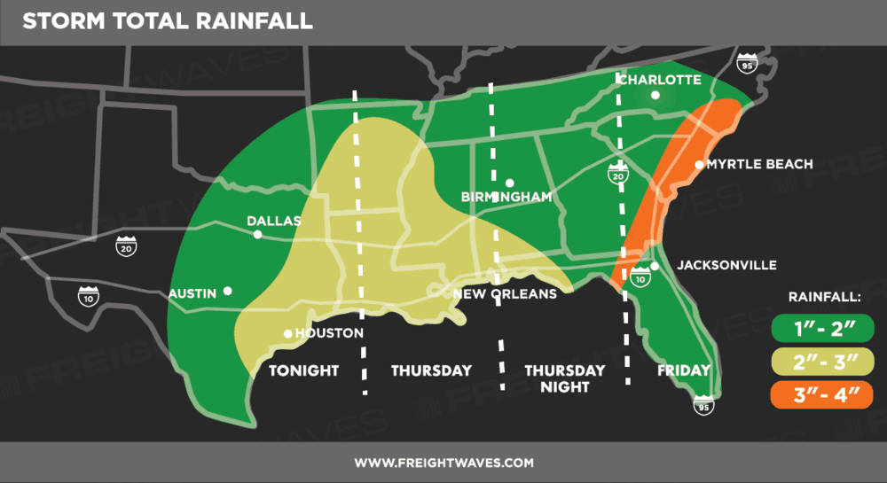
Also, strong to severe thunderstorms could develop across the Gulf Coast, producing extremely heavy downpours and gusty winds of 50 to 60 mph in some spots. For truckers on I-10, I-20, and I-95 this means that, at times, torrential rain will make it hard to see roads and other vehicles ahead of them. They should take breaks during times of limited visibility and/or uncomfortably windy conditions. Drivers might also run into roadblocks, especially where water ends up flooding secondary roads on their routes.
There’s a wintry side to this storm, too. Snow and wind will make travel difficult across the Big Country and Heartland of Texas on Thursday. Up to four inches of snow are forecast for areas along I-20 from Abilene to just west of Fort Worth. For a while the snow could be wet and heavy, and slush will turn icy on roads, driveways, sidewalks, and parking lots.
To make matters worse, strong winds of 45 to 50 mph will lead to blowing snow and poor visibility. The combination of the snow and wind could also knock down trees and power lines, so people should prepare for power outages. A Winter Storm Watch has been issued for these areas. Updates on official alerts for flooding and winter weather can be found on this interactive map.