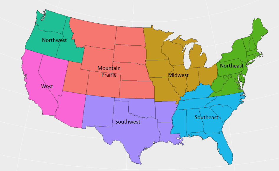
The biggest weather challenges for truckers this week will be snowfall and wind in the Rockies affecting travel in the Mountain Prairie and Northwest regions, as well as heavy thunderstorms across the Southwest and Southeast regions.

There’s already plenty of snow on many roads in southern Wyoming and Colorado where 12 inches or more could pile up before the current storm calms down later on Monday. Winter Weather Advisories and Winter Storm Warnings have been posted in these areas by the National Weather Service. Snow will also fall in Montana, the Dakotas, and northern Idaho.
Roads will be slick, including sections of I-70, and winds will be strong at times, possibly blowing snow right into drivers’ fields of vision. Deadheading or carrying light loads through these areas will be difficult. Drivers should plan breaks to coincide with periods of low visibility, and it’s a good idea to be familiar with chain laws in each state this time of year.
Here’s the breakdown of Monday’s snow event.
Cities of Columbine, Hahns Peak, Toponas, Aspen, Vail, Snowmass, Crested Butte, Taylor Park, Marble, Buford, and Trappers Lake in Colorado:
-
Additional snow accumulations of 1 to 3 inches are expected with totals of 8 to 14 inches. Highest amounts will occur above 8,000 feet, and road closures have occurred over Vail Pass and other roadways, according to the National Weather Service office in Grand Junction.
-
Winds will gust up to 35 miles per hour.
-
Main areas of concern are the Elkhead and Park Mountains, West Elk Mountains, Sawatch Mountains, Gore and Elk Mountains/Central Mountain Valleys and Flat Tops.
Cities of East Slopes Park and Northern Gore Ranges, Gore Pass, Rabbit Ears Pass, Cameron Pass, Laramie and Medicine Bow Mountains, Rabbit Ears Range, Rocky Mountain National Park, Willow Creek Pass, Berthoud Pass, Breckenridge, East Slopes Mosquito Range,
East Slopes Southern Gore Range, Eisenhower Tunnel, Indian Peaks, Kenosha Mountains, Mount Evans, Williams Fork Mountains, and Winter Park:
-
Additional snow accumulations of 2 to 5 inches are expected, mainly north of Cottonwood Pass
-
Winds will gust as high as 50 miles per hour over the higher passes and ridges.
-
Main areas of concern are Rabbit Ears Pass, Rocky Mountain National Park and the Medicine Bow Range, the mountains of Summit County, the Mosquito Range, and the Indian Peaks.
Western Mosquito Range/East Lake County above 11,000 Feet, Eastern Sawatch Mountains above 11,000 Feet:
-
Total snow accumulations of 4 to 8 inches are in the forecast.
-
Gusty winds as high as 55 miles per hour, especially over mountain passes.
-
Areas most affected will be the Western Mosquito Range, East Lake County above 11,000
Feet and the Eastern Sawatch Mountains above 11,000 Feet. This includes SR-91 and US-24 over Fremont and Tennessee Passes, as well as US-50 over Monarch Pass.
Monday night will be a problem from northern Idaho into western Montana where a Winter Weather Advisory will go into effect.
Southern Clearwater Mountains-Bitterroot/Sapphire Mountains:
-
Total snow accumulations of 5 to 8 inches expected above 4,500 feet.
-
Main area of concern will be on US-12 from Lolo Hot Springs in Montana over Lolo Pass to near Powell, Idaho.
Persistent cold temperatures will also cause fuel gelling. Daytime highs this week will remain around or below freezing across large portions of the Mountain Prairie region.
Northeastern Louisiana, eastern Arkansas, western and middle Tennessee, northern Mississippi, and northern Alabama:
Severe thunderstorms will cause issues from from Monday evening through late Monday night. All modes of severe weather – large hail, winds of 60 miles per hour, and tornadoes – are all possible. Some storms will also produce blinding rain which will reduce visibility.
Truckers will have to keep all of this in mind when it comes to planning breaks and deadheading/carrying light loads. This will affect freight movement on several interstate highways, including but not limited to segments of I-10, I-20, I-24, I-40, I-55, and I-65.

Flash flooding could block portions of some routes. Driving through flooded areas is highly discouraged, especially since roads can suddenly wash out under vehicles. Drivers should avoid flooded areas whenever possible and find alternate routes.


