


The South got slammed with record amounts of snowfall last weekend, as well as freezing rain that iced over trees and power lines, knocking them to the ground. North Carolina’s western mountains received 24 inches or more, and cities like Asheville, Charlotte, Raleigh-Durham, Richmond, Spartanburg, and Greensboro/High Point/Winston-Salem (the Piedmont Triad) also got a huge dose of record snowfall on Sunday. These are the totals from Winter Storm Diego:
Asheville, NC (ICAO code: AVL): 11.1 inches
Charlotte, NC (ICAO code: CLT): 2.9 inches
Greensboro/High Point/Winston-Salem, NC (ICAO code: GSO): 12.8 inches
Greenville-Spartanburg, SC (ICAO code: GSP): 4.3 inches
Raleigh-Durham, NC (ICAO code: RDU): 8.9 inches
Richmond, VA (ICAO code: RIC): 11.5 inches
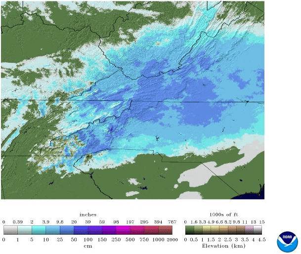
Although the snow has melted in some areas, NOAA satellite measurements show plenty of it still on the ground, especially in the high elevations. Snow has a high albedo, meaning it reflects a lot of the sun’s radiation and energy back into the atmosphere. This keeps temperatures colder where there’s a lot of snow covering the ground, so temperatures in these areas stay too cold to allow much, if any melting.
In areas where snow has melted, it’s likely to refreeze onto roads and other surfaces as temperatures drop into the 20s. The region saw subfreezing temperatures last night, but only for a few hours. Tonight the freezing temperatures will last longer, starting as early as 10 o’clock and lasting until around 8 o’clock Wednesday morning. This could make icing much worse. The National Weather Service has issued a Winter Weather Advisory for Spartanburg, as well as most of western and northern North Carolina for widespread black ice formation.

It’s called ‘black ice’ because the the road appears to be clear or wet, so drivers can see the black top through the ice. However, the ice is often undetectable. Main roads may have only patches of black ice, but untreated secondary roads as well as driveways, sidewalks, and parking lots could end up covered in sheets of it. It’s best to leave for work, school, etc. a little later than usual, if possible. If you must get on the roads, allow for extra time and increase your following distance from the car in front of you.
Lots of accidents were caused by icy roads, and it more could happen tonight or during rush hour tomorrow. ABC-11 in Raleigh-Durham reported that the North Carolina State Highway Patrol responded to more than 2,300 accidents across the state during the storm, as well as 5,800 calls for service. They hope the numbers don’t go up too much.