


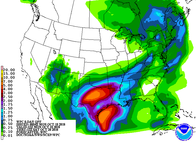
Heavy rain and thunderstorms could slow down drivers early in the week from central Texas to Arkansas to Nashville to the Ohio River Valley. The National Weather Service (NWS) has Flood Watches and Flash Flood Watches issued for Dallas-Ft. Worth to San Angelo to San Antonio.
Smoke from possible wildfires could reduce visibility for truckers in the Los Angeles area, and strong winds could make driving difficult. Santa Ana winds are developing which will dry out the air quickly, so Red Flag Warnings are up until 8 p.m. PDT on Tuesday for the potential for very rapid fire growth. Wind gusts of 40-55 mph will sweep through the valleys and the coast, with gusts of 65-75 mph in the mountains.
Very cold weather with much-below-normal temperatures are expected much ot the week from north Texas to the Dakotas, eastward to the Great Lakes and into New England, with Frost Advisories, Freeze Warnings, and Hard Freeze Warnings in place.
Watch out for snowy, possibly icy roads in northeastern New Mexico where Winter Weather Advisories and Winter Storm Warnings have been issued. This could affect portions of Interstates 25 and 40.
-
WHAT: Snow accumulations of 2 to 4 inches, with 6 to 12 inches above 7,500 feet. Snow will mix with freezing drizzle or change to freezing drizzle at times across Union County, the Central Highlands, the Northeast Highlands and the Far Northeast Highlands. Wind chills in the teens and single digits will also be likely.
-
WHERE: Sangre de Cristo Mountains, Upper Rio Grande Valley, Central Highlands, Raton Ridge and Johnson Mesa, Far Northeast Highlands and Northeast Highlands, and Union County.
-
WHEN: Through noon MDT on Monday.
-
ADDITIONAL DETAILS: Significant reductions in visibility are expected. Wet snow falling on lingering foliage may result in isolated power outages. Black ice will be possible as arctic air causes water on road surfaces to freeze rapidly.

Weather along the Florida Panhandle should be relatively quiet as clean up and recovery from Hurricane Michael continue. Just daily chances there pop-up showers/thunderstorms.