


Hurricane Sam continues its journey across the tropical Atlantic, packing powerful winds on its way to the Caribbean.
Sam became a Category 4 hurricane Sunday, with sustained winds reaching 150 mph. It weakened to a Category 3 storm Monday, jumping back to Category 4 early Tuesday.
Related: How and why do hurricanes get their names?
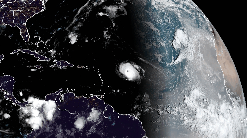
At that time, Sam was centered about 600 miles east of the northern Leeward Islands in the Caribbean. It was a major hurricane with maximum sustained winds of 130 mph, along with higher gusts. The National Hurricane Center expects some fluctuations in intensity during the next couple of days, but is forecasting Sam to remain a major hurricane (Category 3 or higher) through late this week.
Even though Sam isn’t a large hurricane, its wind field has expanded. Hurricane-force winds extend outward up to 40 miles from the center (compared to 30 miles Monday), and tropical storm-force winds were recorded up to 125 miles from the center, up from 105 miles Monday. Tropical storm-force winds in large hurricanes often extend 150 miles or more from their centers.

Sam is creeping toward the northwest at about 9 mph. The National Hurricane Center expects this motion to continue for the next few days, with an increase in forward speed beginning Thursday. This should be followed by a turn toward the north by Friday. On this forecast track, Sam will pass well to the northeast of the northern Leeward Islands Wednesday and Thursday, avoiding a direct hit. After that, Sam will slide to the east of Bermuda by Saturday.
Sam will produce big, potentially dangerous waves for container ship crews and surfers alike. Swells generated by Sam will reach the Lesser Antilles the next few days. Swells are expected to reach Bermuda and the Bahamas in a couple of days, and then spread to the U.S. East Coast late this week.
Sam is the seventh hurricane of the season. Over the past 30 years, the average date for the seventh Atlantic hurricane formation is Nov. 16 (the season officially ends Nov. 30), according to Philip Klotzbach, a meteorologist at Colorado State University who specializes in tropical weather. So, Sam is way ahead of schedule.
Two other disturbances in the tropical Atlantic between Africa and the Caribbean have high chances of developing into tropical depressions or tropical storms sometime this week. If they become tropical storms, the next two names would be Victor and Wanda.
Click here for more FreightWaves articles by Nick Austin.
You might also like:
Self-described ‘shaman’ arrested in California wildfire arson
Wildfire crews battling blazes — and supply chain kinks
Hours-of-service relief part of response to historic Minnesota drought
