


Updated Friday, Sep. 18, 2020, 1:30 p.m. ET
A tropical storm could hit the continental U.S next week, after Hurricane Sally devastated parts of the northern Gulf Coast just a couple of days ago.

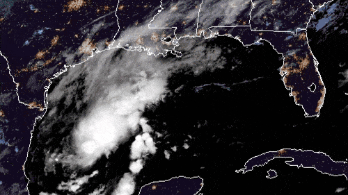
Tropical Depression 22 (TD 22) is wobbling around the southern Gulf of Mexico (GOM), about 300 miles southeast of Brownsville, Texas.
TD 22 will slowly organize as it moves to the north and rapid intensification (RI) isn’t likely. The system will probably peak as a strong tropical storm or low-end Category 1 hurricane. However, as is the case with any storm in the Gulf of Mexico in a favorable environment — very warm sea surface temperatures (SSTs) and weak wind shear — things can change quickly and there is a small chance that TD 22 could undergo RI.
As for its path, TD 22 will continue to move slowly to the north before turning to the west, approaching the Texas coast. As the storm approaches the coast, upper-level steering winds may weaken. This would cause TD 22 to slow down and possibly stall close to the coast.
TD 22’s biggest impact will be periods of torrential rainfall and the potential for significant flooding along the Texas coast and possibly areas just inland. Precise totals cannot be predicted at this time, but the National Weather Service (NWS) forecast for southern Texas shows totals of 6 to 10 inches in some areas through the idle of next week. The worst conditions will probably hit southern Texas, but heavy rainfall could spread to the upper Texas and southwestern Louisiana coasts too.
Impacts from storm surge and winds will likely be on the minor side. Those with network assets in the region are advised to watch this storm closely for further developments and changes to the forecast.
Meteorologists at the National Hurricane Center (NHC) give TD 22 a high chance of becoming a tropical storm later Friday, possibly a hurricane by Sunday.
If TD 22’s sustained winds reach 39 to 73 mph, it will become a tropical storm. All of the “regular” names of the 2020 Atlantic have been used, since Tropical Storm Wilfred formed in the eastern Atlantic just a few hours after this article was originally posted.
Future names will start with Greek letters. Subtropical storm Alpha formed near the coast of Portugal shortly after Wilfred. If TD 22 becomes a tropical storm, it will be named Beta, unless another disturbance beats it to the punch. After that, the next name is Gamma. The last time that storm names began with Greek letters was in 2005.