


Allow some extra time to get your trucks warmed up! It’s going to be a colder-than-normal, frosty start to the week from Arkansas eastward to the Tennessee and Ohio River Valleys, and from the Carolinas to the Mid-Atlantic states, especially in the mountainous regions.
Scattered showers and thunderstorms could slow you down across parts of the Desert Southwest (Four Corners Region) in Arizona, Colorado, New Mexico and Utah on Monday and Tuesday. Storms could produce heavy rain, strong winds, and hail. This would mostly affect routes on Interstates 15, 25, 40, and 70.
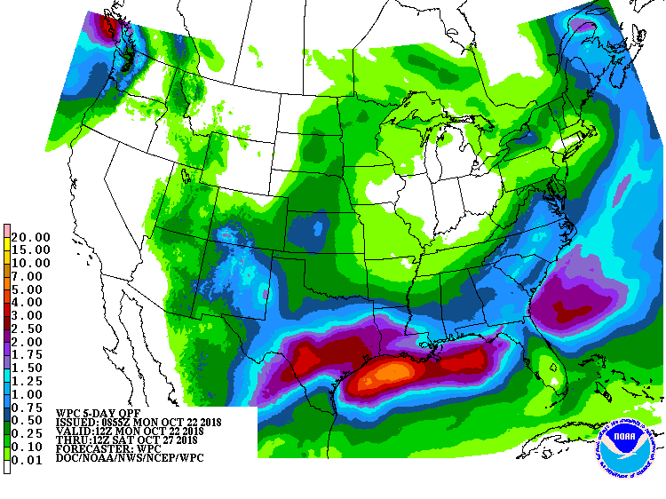
Persistent, widespread rain will soon cause problems along the I-10 corridor as the remnants of Hurricane Willa move eastward across Mexico and into the U.S. by mid-week. Rain totals of 3 to 5 inches are possible Tuesday through Friday, with locally heavier amounts, from near San Antonio to Brownsville, and from Houston to Lake Charles, Louisiana. Areas of flooding are likely and could lead to road closures. The FM 2900 bridge remains closed going over the Llana River and Lake LBJ in Kingsland, Texas because of flooding from last week. Other state and local roads in the Lone Star State remain closed due to flooding. Check updates on this web site.
Besides Willa in the Pacific, there’s also Tropical Storm Vicente which could make landfall on the western coast of Mexico by Wednesday. Current forecasts have it hitting just south of Puerto Vallarta.
Meanwhile, thick fog will get in your way Monday morning in the Seattle-Tacoma area of the Pacific Northwest, so be extra careful on the 5 and the 405. Stagnant air, along with smoke and other pollutants, will lead to poor air quality for at least another couple days in interior portions of Washington and Oregon. This would affect routes from Spokane and Yakima southward to Pendleton, Redmond, and Walla Walla, including Interstates 84 and 90.
Snowfall of 8 to 12 inches could fall in interior portions of Maine Tuesday night through Wednesday. This would affect local and state routes near the Quebec border.
Early indications are that a Nor’easter could dump heavy rain and snow on the Mid-Atlantic and New England states Sunday and next Monday, along with gusty winds. Long-range forecasts estimate several inches of additional snow for interior portions of Maine, and up to 12 inches of new snow for other areas of New England, affecting Interstates 87, 90, 91, 93, and portion of 95.

Major weather hazards expected, October 22-26. (Source: NOAA)
